 Credit: Adobe Stock
Sports watches cannot compete with precision GNSS receivers. Some watches measure distance with an accuracy of 1 meter or less, while others measure distance with an error exceeding 20 meters. They are not suitable for measuring altitude either, they often do not register that they are climbing with a wearer, scientists from the Wrocław University of Environmental and Life Sciences in have found.
Sports watches are equipped with receivers of various satellite systems, which differ, among other things, in terms of the used time system or the structure of the code emitted by satellites, which causes differences in the form of signal decoding delays. When the satellite receiver in your watch does not properly account for the differences between GPS, GLONASS and Galileo, positioning errors are greater than when using a single satellite system.
Scientists from Wrocław verified the accuracy of sports watches in terms of satellite positioning relative to a precise geodetic receiver. They checked distance measurements on an athletics track and altitude difference measurements on an observation tower. The research results were published in Measurement https://doi.org/10.1016/j.measurement.2024.114426
Satellite receivers in sports watches
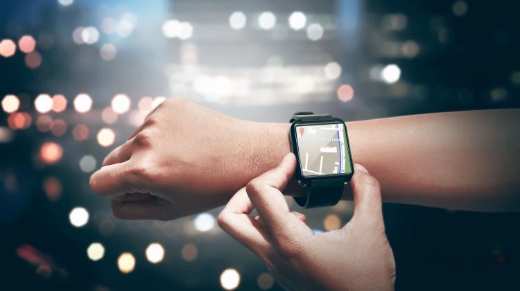
Sports watches with GNSS (Global Navigation Satellite System) are used in both professional and amateur sports. For example, they enable runners to accurately track their route. Modern models support several satellite systems at once, which improves the time of obtaining the initial position. Manufacturers are supported by applications for analysing results and interacting with other users. Sports watches provide a lot of information that can be practically used.
'Sports watches are often used by scientists who study various aspects of sports physiology and performance, including running, kayaking and triathlon. Despite their wide use, official manufacturer or seller websites often fail to provide detailed information on the accuracy of satellite positioning for specific sports watch models. The lack of accuracy specification motivates researchers and enthusiasts to delve deeper into this topic', explains Professor Krzysztof Sośnica from the Institute of Geodesy and Geoinformatics of the Wrocław University of Environmental and Life Sciences.
Scientists from Wrocław assessed the precision of positioning in two dimensions, distance and height difference in sports watches. They included various combinations of GNSS systems. They conducted experiments related to measuring distances and height differences in three GNSS configurations: GPS (global), GPS+GLONAS (global and Russian) and GPS+Galileo (global and European).
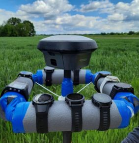
'We used ten different sports watches from three manufacturers (Garmin, Polar, Suunto): Suunto 5 (S_5), Suunto Ambit3 (S_Amb3), Garmin Forerunner 735XT (G_Fr735), Garmin Forerunner 745 (G_Fr745), Garmin Fenix 6 PRO (G_6PRO). ), Garmin Vivoactive 3 Music (G_V3M), Garmin Vivoactive 4s (G_V4s), Polar Grit X (P_GritX), Polar M430 (P_M430), Polar Vantage V (P_Vant_V)', the professor says.
He explains that watches typically support three GNSS systems, but use two at the time during activities, depending on the user's preferences. They also allow to adjust the position tracking mode to your needs and battery life.
Experiments: positioning, height and distance
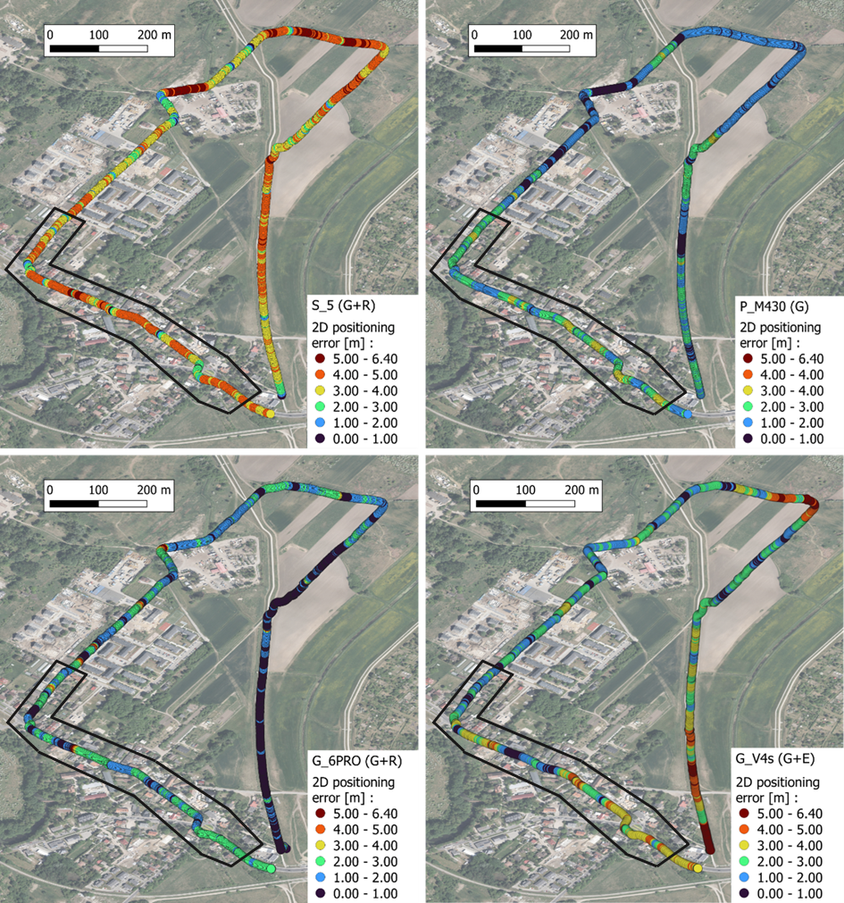
The first experiment was carried out on an approximately 2.7 km long test route in Wrocław. The route included areas with varying sky visibility.
'The reference was the professional geodetic GNSS receiver Leica GS18. The geodetic receiver uses real-time corrections from the WROC reference GNSS station. It guarantees positioning accuracy of less than 3 cm and height accuracy of less than 5 cm. Sports watches and the receiver were placed on a geodetic pole using an additional frame', describes Professor Krzysztof Sośnica.
The largest errors occurred in areas surrounded by buildings or trees. In areas with fewer obstacles, the positioning accuracy of the watches was higher. High-stability sports watches exhibited variable positioning accuracy between unobstructed areas and areas with horizon obstructions.
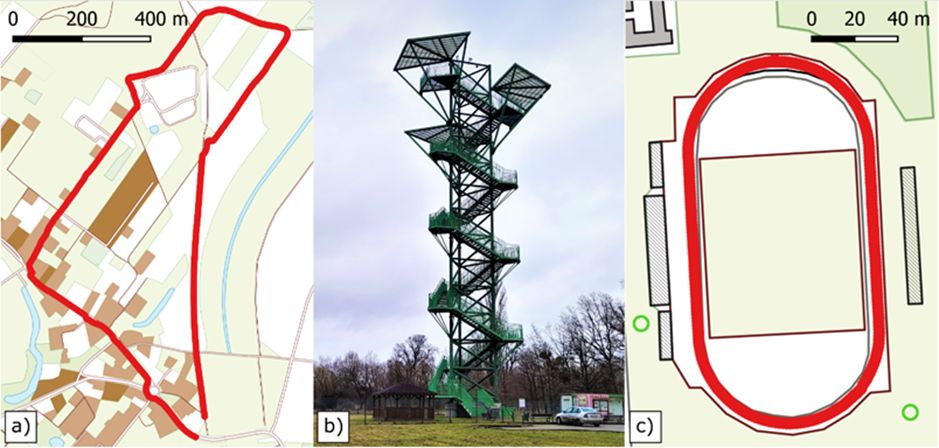
Conducted tests for sports watches a) positioning field test for determination of horizontal coordinate components, b) height measurement experiment, c) distance measurement experiment on the athletics track. Credit: Wrocław University of Environmental and Life Sciences
The researchers confirmed that lower quality sports watches show this difference less clearly. 'This is due to high signal noise in the GNSS module of individual devices, resulting in low positioning accuracy even under ideal conditions, unlike more stable sports watches', they explain.
The altitude experiment was conducted on a steel tower with a height of 36.83 m, located in Kotowice near Wrocław. Measurements were conducted on 13 levels, spaced approximately 2.9 m apart. Height differences were measured using a laser rangefinder to provide a valuable reference of the height differences between different platform levels of the tower. In each GNSS configuration at each tower platform, the sports watches were held in place for over 3 minutes in order to record a similar number of observations at each platform.
It turned out that watches were not suitable for measuring height. Despite the increase in height, some models showed lower readings at higher levels on the tower. Only two models of sports watches showed an increase in value at each subsequent level at which measurements were taken. However, at some levels the differences between their results and the reference were expressed in meters.
The distance experiment was conducted out on a full-size athletics track in Wrocław. The inner edge of the track is 400 m long. In each GNSS configuration, experimenters completed five laps on the second track, which was 407.67 m long.
In the track distance experiment, different sports watch models showed different accuracy depending on the selected constellation. The most precise result was the one with the difference between the length of the track and the sports watch measurement of 0.49 m, which - in the researchers' opinion - was acceptable considering the low cost of the device with a GNSS receiver.
Sports watches do not achieve astonishingly high accuracy compared to the results obtained by high-precision GNSS receivers. Some watches provide distance measurement errors of less than 1 m, while others have errors of more than 20 m in the same experiment. For 2D positioning, the best watches provide an average error of 1.4 m, the worst ones - 4.2 m.
'Sport watches are low-cost receivers typically capable of tracking more than one GNSS constellation. However, due to hardware limitations in most models available on the market, it is only possible to utilize two GNSS systems simultaneously. The GPS is always employed, and it is possible to select a second constellation, such as GLONASS, Galileo, or BeiDou', the researchers explain in the paper.
Detailed results for individual manufacturer brands can be found in the paper https://doi.org/10.1016/j.measurement.2024.114426 in Measurement. Its co-authors are: Marcin Mikoś, Dr. Kamil Kazmierski and Natalia Wachulec from Professor Krzysztof Sośnica's team.
'In the future, technology could enhance GNSS signal tracking and position calculation algorithms', the researchers predict in their paper.
PAP - Science in Poland, Karolina Duszczyk
kol/ agt/ kap/
tr. RL
Przed dodaniem komentarza prosimy o zapoznanie z Regulaminem forum serwisu Nauka w Polsce.